Have you ever used a tube map to navigate around London? Imagine, if the underground map was on the ground and instead of stations it links together green spaces, waterways & walking paths. London Greenground Map aims to reimagine London in a new way, inspiring to explore the city in a more sustainable, open and healthier way via its green & blue spaces.
Connect with your local nature reserve or embark on a city-wide adventure via one of the London long-distance paths – with 1,200 parks & open spaces and 20 green & blue lines the options to explore are infinite.

Explore the map online
For online access, click on the map below to open the high-resolution image in open-source viewing app Zoomhub. Zoom in and out freely and toggle full page for a closer view. The home button takes you back to the main view. Happy exploring!

Download the map to your own device
For digital file, press the button below to download the full-scale map into your own device. You’re welcome to print it out and keep the file for your personal use indefinitely. For all public uses (eg sharing it on blog posts) please get in touch via helen.ilus@outlook.com.
Contribute
I hope you are enjoying this open resource. If you haven’t yet contributed, but would like to do so now, please click here to make a donation. All contributions are greatly appreciated!
PayPal is not for you? Try Stripe
Growing edition – bonus content
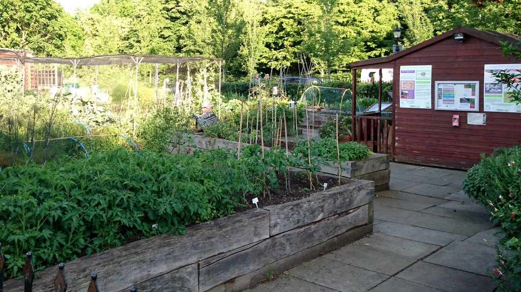
This special edition Greenground Map aims to connect Londoners with opportunities to grow food. According to Capital Growth Network London has over 2000 growing spaces. In this experimental map highlighting some of them, the preference has been made to those always open to the community or with public-facing events through growing days and volunteering. The map aims to inspire everybody to have a go at community gardening and as a result, be inspired to grow their own food.

Do you like this map? Check out the cycling edition
Resources & data
This resource is based on publicly available data sources and articles. Here you have an open access to explore this information further.
Google Maps 2023
OS Open Greenspace data 2023
TFL Walk London – Routes / Inner London Ramblers guides, 2023
Natural England, Local Nature Reserves, 2023
Air quality in London’s parks – A study conducted by Imperial College London and the University of Leicester, 2019
Traffic Noise in London’s Parks: Research and Report May 2018, CPRE London
Cool Spaces Map | London City Hall, 2023
River Services map and London Trams map, TFL 2023
Natural England, England Coast Path Route, 2023
List of Sites of Special Scientific Interest in Greater London, Wikipedia 2023
List of local nature reserves in Greater London, Wikipedia 2023
the-line.org, 2023
Where To Go Birdwatching In London, Londonist 2016
Parks & Open Spaces data sheet, HI 2024
Lines
Thames Path https://www.nationaltrail.co.uk/en_GB/trails/thames-path/
Regent’s Canal https://canalrivertrust.org.uk/canals-and-rivers/regents-canal
Grand Union Canal https://canalrivertrust.org.uk/canals-and-rivers/grand-union-canal
Capital Ring https://innerlondonramblers.org.uk/ideasforwalks/capital-ring-guides.html
Wandle Trail https://www.merton.gov.uk/leisure-recreation-and-culture/tourism-and-travel/local-attractions/the-wandle-trail
Wandle Valley Park https://wandlevalleypark.co.uk/map/
England Coast Path https://www.nationaltrail.co.uk/en_GB/trails/england-coast-path/
Lea Valley Walk https://tfl.gov.uk/modes/walking/lea-valley
London LOOP https://www.innerlondonramblers.org.uk/ideasforwalks/loop-guides.html
River Ravensbourne https://en.wikipedia.org/wiki/River_Ravensbourne
River Roding https://en.wikipedia.org/wiki/River_Roding
Green Chain Walk https://www.innerlondonramblers.org.uk/ideasforwalks/green-chain-walk-guides.html
Crane Valley Trail https://www.cranevalley.org.uk/crane-valley-trail/
Friends of the River Crane Environment / Crane Valley Partnership / Headstone Manor Park
Dollis Valley Greenwalk https://www.barnet.gov.uk/parks-sport-and-leisure/walks-and-trails/dollis-valley-greenwalk
Brent River Park https://www.brentriverpark.org/explore/
Royal Parks – Greenground Map line https://www.royalparks.org.uk
City – Greenground map line
Bee B-Line https://www.gigl.org.uk/2023/02/16/londons-new-b-line/
North – Greenground map line
South – Greenground map line
Art Line https://the-line.org
Tram https://content.tfl.gov.uk/tram-service-map.pdf
Hill – Greenground map line https://en.wikipedia.org/wiki/List_of_highest_points_in_London
Growing Edition
Capital Growth https://www.capitalgrowth.org/spaces/
London Permaculture https://www.londonpermaculture.com/map/
Social Farms & Gardens https://www.farmgarden.org.uk/your-area/london
ⓘ Green spaces under threat
London parks, open spaces and wildlife reserves are under constant threat from urban expansion, however, activists, naturalists and regular Londoners are fighting back!
Here are some ongoing campaigns you can currently support to save London’s green spaces from (over)development:
Save Victoria Tower Gardens
http://www.savevictoriatowergardens.co.uk
Save Warren Farm
http://www.warrenfarmnaturereserve.co.uk
Save Wimbledon Park
http://www.savewimbledonpark.org
Colne Valley Park
http://www.colnevalleypark.org.uk/whats-special/safeguardthecountryside/
Whitewebbs Park
https://www.crowdjustice.com/case/save-whitewebbs/
Save Shirley Heath and Addington Hills
https://www.change.org/p/save-shirley-heath-and-addington-shirley-hills
Save Lea Marshes
http://www.saveleamarshes.org.uk

